New technology transforms pest control
Matariki Forests has introduced new technology in its Hawke’s Bay forests to strengthen its pest control efforts and stay one step ahead of environmental threats.
While thermal drones have been used in search and rescue and for mapping fires, it is only recently they have been deployed in forestry for mapping and monitoring. Now new possibilities have opened up in protecting plantations. Matariki Forests, in conjunction with pest control specialist, Thompson Twins Contracting, have been trialling this innovative approach to pest monitoring and control.
Leigh Smith, Matariki Forests Hawke’s Bay regional manager, says thermal drones have been a game changer.
“Pests such as possums, goats, and deer can cause major damage to young pine stands. They eat new growth, strip bark, and disturb native species living in and around plantation forests,” says Leigh.
“We can work smarter, implementing more targeted pest control work which causes minimal disturbance to the surrounding environment and sensitive ecosystems.”
Traditional pest control often depends on people driving or walking over steep terrain or dense cover at night, shining spotlights and looking for movement - work that is tiring, has risks, and is sometimes unreliable.
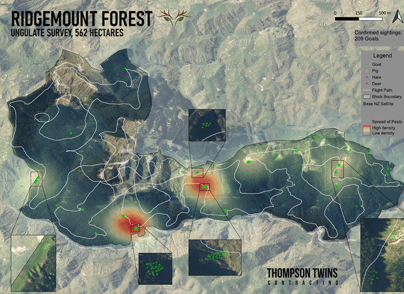
Thermal cameras detect heat differences rather than relying on visible light. That means animals show up as bright, clear shapes even when hidden by shadows or vegetation. Drones equipped with these cameras can fly over large areas quickly, picking up the heat signatures of pests early in the morning, at dusk, or at night. This makes it possible to pinpoint the exact spots where pests are active.
Once high-density hotspots have been identified thermally assisted helicopter shooting takes place, followed up by ground hunters supported by trained detection dogs.
The drone footage feeds directly into digital maps, which Matariki Forests already uses for planning and site management, creating a full picture of where pests move and how numbers change over time.
“Thermal drones can scan in a couple of hours what would take ground-based surveys days or weeks to achieve, with the risk of missing animals due to being in the right place at the wrong time.
“Using this technology as part of an integrated pest management plan has been cost effective and delivered results. We’ve really increased our efficiency and effectiveness in getting on top of pest species and protecting the forests.”
Drone map showing pest hot-spots and Ben Thompson, pest control contractor, with his dogs.